The staff at Magdalene College Libraries are pleased to host a blog post by Alexandra Charlton-Jones, an MPhil student in Medieval and Renaissance Literature, who has made a study of our 1652 edition of Peter Heylyn’s ‘Cosmographie’ in the Old Library:
Tucked away in the Old Library at Magdalene College, Cambridge, is the 1652 edition of Peter Heylyn’s Cosmosgraphie, a compendium that anatomises each continent of the world by exploring the history and topography of its constituent countries. Heylyn (1599–1662) was a clergyman and historian, whose most known works are in the field of historical geography; namely, Microcosmos (1621) and its expanded version, Cosmographie (1652). The latter work, and more specifically its four maps that introduce the books on Europe, Asia, Africa and America, are of particular interest to us here; these detailed engravings capture the eye with their images of sea creatures, ships and exotic animals. Given the importance of visual elements in this book, and the content of the text itself, Cosmographie offers an interesting perspective on the relationship between the visual and the textual, between seeing and reading, and how this relationship is affected by the complexities of the early-modern printed book.
What happens when we look at these maps from a purely visual standpoint, when we ignore the impulse to read their inscriptions? When viewing the maps from that angle, our eyes drift to the figures that co-inhabit the otherwise blank space of the oceans: ships and sea creatures. In fact, these seemingly decorative cartographic details can offer us a new way of looking at Cosmographie as a whole. Take the sea creatures, for instance. They are rather (un)remarkable in comparison with the monsters that have surfaced in maps over the preceding centuries; sea dragons, sirens and “saw fish” (which cut ships in two) are some examples of the fearsome and fantastical beasts that have held a prominent place in scientific discourse, popular imaginations and (therefore) maps from the tenth to the sixteenth century.[1] However, by the seventeenth century, scientific discoveries paired with colonial and trade expansion meant that more accurate accounts of marine life were proliferating, and so sea monsters began to be replaced by sea animals. As Chet Van Duzer points out in Sea Monsters on Medieval and Renaissance Maps (2013), this in turn meant that ships started occupying more and more space on maps.[2] In other words, the monsters’ supremacy over cartographic oceans gave way to ships as mankind claimed increasing supremacy of the seas. This demystification of the ocean can be seen in Cosmographie through the vessels and the rather generic creatures that occupy the page; this shows us that the mystical beasts that once signified the unknown and even fearful aspects of the ocean have shifted into signifiers of human agency and conquest.

The more generic creatures on the map of Africa in this Magdalene Old Library copy of ‘Cosmographie’, G.11.5.
If we now start to take the inscriptions on these maps into account – still without reading them “too much” – the distribution of inscriptions on the landmasses offers a similar insight into what are, so far, the non-textual ideas behind Cosmographie.[3] What is perhaps most striking is the fact that Europe is filled entirely with writing, while other continents contain a mixture of inscriptions and images; Africa is dotted with animals (such as lions and camels), an elephant stands in the northern regions of India, while a house and its two inhabitants occupy a large area of southern America. These details can be seen as adding a zoological aspect to the otherwise geographical information given here, which would contribute to the classification of these continents in both the maps and text of the book – or are they just visual padding? For while Europe is scrawled over with names, locations, information, at this point in time the space on these foreign landmasses is only – or can only be – filled with pictures. So, on the one hand the maps in Cosmographie offer an instance of how cartographic signifiers of mystery and fear evolved into signifiers of boldness and knowledge; and yet, on the other hand, the giving over of cartographic space to images in these other, exotic continents implies that there is both a representational and epistemological gap that is yet to be filled.

Map of Africa with animal detailing

The map of America.

A zoom on the house detail, on the map of America.
In the appendix to Cosmographie, which attempts ‘a discovery of the unknown parts of the world’, Heylyn addresses the fact that an (artistic) impulse to fill up blank space on a map can mar our knowledge of the globe. These ‘unknown parts’ refer chiefly to both terre incognite, Australis and Borealis, which were mystical – but not entirely mythical – locations in the uppermost and lowermost expanses of the world. In The Phantom Atlas (2016), Edward Brooke-Hitching offers a brief history of Terra Australis as it appears in theory and, later, in cartography from Aristotle onwards.[4] In this case, Heylyn uses this location as a catch-all for many other fantastical and phantasmal places of the world; for instance, he claims that the lands described by Thomas More in Utopia (1516) could be ‘fitted only to the Meridian of this Southern Continent, this Terra Australis Incognita, in which now we are, and to no place else’.[5] He also cites the example of Don Pedro de Sarmiento, a Spanish gentleman who was asked about the location of Terra Australis by Sir Walter Raleigh,
To which he merrily replied, that it was to be called the Painters Wives Iland, saying, that whilest the Painter drew that Map, his wife sitting by, desired him to put in one Countrey for her, that she in her imaginations might have an Iland of her own. His meaning was, that there was no such Iland as the Maps presented. And I fear the Painters Wife hath many Ilands and some Countries too upon the Continent, in our common Maps, which are not really to be found on the strictest search.
Heylyn is therefore aware that maps can both inform and misinform, and that the fault in the image rests not only with the artist, but also with those that surround the creative process. Therefore, in a kind of safety net manoeuvre, Heylyn relegates the more overtly fictional realms to this textual space, which signals only to potential geographical spaces. This, in turn, implies a great power in the map; what it presents makes a great claim to veracity, so much so that Heylyn conjoins this area of uncertainty with a textual justification (for Terra Australis Incognita does appear on the map of America – as do, we might appreciate, Lake Panime and El Dorado).
The power of the image and its relationship to the text brings us to another consideration about Cosmographie and its enchanting maps: how are we meant to read images, like maps, in the context of the early-modern printed book? Texts from this period were often filled with decorative pictures and patterns (such as woodcuts and printers’ ornaments) which – consciously or not – we might bypass when reading the book. In the case of this particular text, these peripheral images also offer an otherwise unarticulated insight into the work as a whole. In a case similar to the painter and his wife, these images serve to expose the vulnerability of the printed text as a medium for transferring information. Indeed, the very idea of filling space on maps with visual details echoes the process of filling space on the printed page with printers’ ornaments. Although Cosmographie was published during the Interregnum, a few of these decorations bear royalist connotations; for instance, the ornament on the title page of Book Three depicts a fleur-de-lis and a harp, topped with crowns, while the title page of Book Four, Part I, bears a Tudor Rose and crown. The heading of the chapter on India is a row of stylised crowns, interspersed with the odd question mark. It could be argued that those question marks stand for our attitude as readers, or viewers, of these images; are they codes or simply decorative? Not all of these ornaments have them, but their presence permeates the book, including the maps. Robert Vaughan, the engraver of the European map, was a royalist supporter during the Civil Wars, and in 1651 he was indicted for publishing a printed portrait of Charles II. Before the conflict, Heylyn himself was (among other roles) chaplain-in-ordinary to Charles I, and he came under fire from Commonwealth authorities shortly after the king’s execution. We are therefore reminded of the painter and his wife here, in that the multifarious roles involved in producing an early-modern book allowed for different messages to be folded into the printed text, while the many decorations and elements of that printed text could also make good hiding places.

The ornament at the heading of the India chapter, with its crows and question marks.
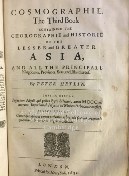
The title page for Book Three, with its fleur-de-lis, harp and crown ornaments.
The early-modern printed book is a much more composite work than it seems, and when thinking of both its textual and visual elements we should realign our seeing and reading impulses. But in doing so, and in the elements that have been discussed, another question arises: in this case, does the map illustrate the text or does the text serve to explain the contents of the map? We are discussing a book as opposed to a standalone map after all. In this respect we can turn to Gérard Genette’s Paratexts: Thresholds of Interpretation (1997) as a seminal work that deals with the various elements of the printed text that stand outside of its main body. Indeed, the maps can certainly belong to the category of paratext, but in this instance perhaps they contribute to another kind of extratextual message that the text of Cosmographie only gestures towards. To take the example of colonialism, this text does not claim ownership over certain parts of the world but strives for an objective rendering of their history and geography; however, the animals over Africa, rather like the sea creatures, appear to be non-threatening, exotic depictions of the denizens of the lands that the coloniser and tradesman have come to master. Although the text does not explicitly state it, its visual elements (perhaps unintentionally) imply a Eurocentric view and interpretation of the world. From the ships mastering the oceans to the disparity between an inscribed representation of Europe and a more illustrated depiction of Africa, the images in Cosmographie can make us see (and so read) the text itself in a different way.
By Alexandra Charlton-Jones
MPhil Student, Lucy Cavendish College
[1] See Chet Van Duzer, Sea Monsters on Medieval and Renaissance Maps (London : British Library, 2013).
[2] Ibid, p. 118.
[3] For another example of bibliographic “seeing without reading”, see (or read) Randall McLeod, ‘from Tranceformations in the Text of “Orlando Furioso”’, in New Directions in Textual Studies, ed. by Dave Oliphant and Robin Bradford (Austin, Tex.: University of Texas, 1990).
[4] Edward Brooke-Hitching, The Phantom Atlas: the Greatest Myths, Lies and Blunders on Maps (London: Simon & Schuster, 2016), pp. 224-29.
[5] Letterforms have been modernised; another literary location in the Appendix is Faerieland from Edmund Spenser’s Faerie Queene.
BIBLIOGRAPHY
Primary Source:
Heylyn, Peter, Cosmographie In Foure Bookes Containing The Chorographie And Historie of the whole World, And all the principall Kingdomes, Provinces, Seas, and Isles, thereof., Old Library, Magdalene College, Cambridge (G.11.5.)
Secondary Sources:
Brooke-Hitching, Edward, The Phantom Atlas: the Greatest Myths, Lies and Blunders on Maps (London: Simon & Schuster, 2016)
McLeod, Randall, ‘from Tranceformations in the Text of “Orlando Furioso”’, in New Directions in Textual Studies, ed. by Dave Oliphant and Robin Bradford (Austin, Tex.: University of Texas, 1990)
Van Duzer, Chet, Sea Monsters on Medieval and Renaissance Maps (London : British Library, 2013)
